 Feds halt activist deportation
 'Smart' lawyer suspended
 First Nation solar farm plans
 Searching landfill for woman
 Poland urges more spending
 Cutting rates at own pace
 Israeli strike played down
 Full Trump jury seated
 World's largest election
  Lawsuit over missing nuts
 Investigating pipeline blast
 TikTok testing new app
 Warriors ready for Round 2
 Kalamalka Bowl cancelled
 Rockets live to fight on
 Hilton teams up with Sia
 Swift still 'can't forgive' Kim
 Grimes to ‘cap the disarray’


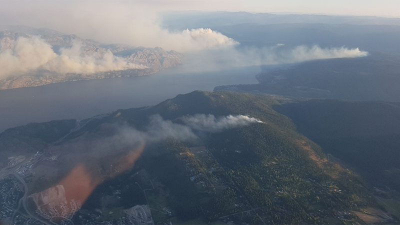
Central Okanagan fire history (See first post)
-
Frisk

- Guru
- Posts: 9263
- Joined: Apr 24th, 2011, 9:32 am
Central Okanagan fire history (See first post)
This list shows notable fires in the Central Okanagan in recent years. I also included some notable fires in the Summerland and Penticton area's due to the close proximity.
____________________________________________________________________________________________________________________________
Garnet
Cause: Most sources say arson
Location: East Penticton
First detected: July 20th, 1994, mid evening
Size: 5500 hectares
Evacuated: 3500 people
Structures damaged / destroyed: 18 homes
____________________________________________________________________________________________________________________________
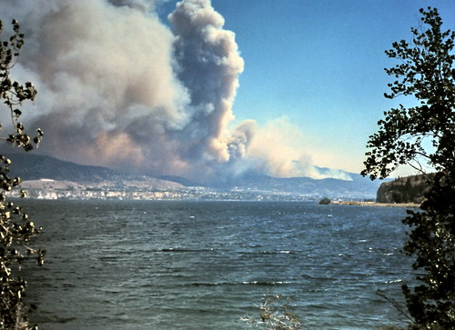
Okanagan Mountain Park
Cause: Lightning
Location: South Kelowna, Okanagan Mountain Park
First detected: August 16th, 2003, early morning
Size: 25912 hectares
Evacuated: 33000 - 37000 people
Structures damaged / destroyed: 239 homes, 14 trestles

____________________________________________________________________________________________________________________________
Rose Valley
Cause: Campfire
Location: East side of Rose Valley Lake
First detected: August 27th, 2005, late evening
Size: 25 hectares
Evacuated: 75 properties
Structures damaged / destroyed: None

____________________________________________________________________________________________________________________________
Glenrosa
Cause: Human, exact cause unknown
Location: South Glenrosa
First detected: July 18th, 2009, mid afternoon
Size: 303 hectares
Evacuated: 4500 properties
Structures damaged / destroyed: 4 homes

____________________________________________________________________________________________________________________________
Terrace Mountain
Cause: Human, exact cause unknown
Location: Fintry protected area
First detected: July 18th, 2009, afternoon
Size: 9277 hectares
Evacuated: 2500 people
Structures damaged / destroyed: None

____________________________________________________________________________________________________________________________
Rose Valley
Cause: Human, exact cause unknown
Location: West side of Rose Valley Lake
First detected: July 18th, 2009, late evening
Size: 107 hectares
Evacuated: 2000 properties
Structures damaged / destroyed: None

____________________________________________________________________________________________________________________________
Seclusion Bay
Cause: Tree fell on power line
Location: Drought Hill
First detected: July 12th, 2010, late morning
Size: 30 hectares
Evacuated: 20 properties
Structures damaged / destroyed: 1 home, 2 garages

____________________________________________________________________________________________________________________________
Bear Creek
Cause: Human, exact cause unknown
Location: Bear Creek Provincial Park
First detected: September 5th, 2011, late evening
Size: 39 hectares
Evacuated: 550 people
Structures damaged / destroyed: None

____________________________________________________________________________________________________________________________
Wilson's Landing
Cause: Lightning
Location: Above Wilson's Landing / Westside road
First detected: July 28th, 2012 (believed to have started the previous evening)
Size: 29 hectares
Evacuated: 50 properties
Structures damaged / destroyed: None

____________________________________________________________________________________________________________________________
Peachland
Cause: Human, exact cause unknown
Location: Trepanier valley
First detected: September 9th, 2012, mid afternoon
Size: 200 hectares
Evacuated: 1550 people
Structures damaged / destroyed: 4 homes, 3 outbuildings

____________________________________________________________________________________________________________________________
Smith Creek
Cause: Human, exact cause unknown
Location: North of the Smith Creek subdivision
First detected: July 17th, 2014, early afternoon
Size: 340 hectares
Evacuated: 2500 people
Structures damaged / destroyed: None

____________________________________________________________________________________________________________________________
Drought Hill
Cause: Human, exact cause unknown
Location: Above Trepanier beside Highway 97C
First detected: August 7th, 2014, mid afternoon
Size: 40 hectares
Evacuated: 1 property
Structures damaged / destroyed: None

____________________________________________________________________________________________________________________________
Highway 33
Cause: Carbon from vehicle exhaust
Location: North beside highway 33 in Joe Rich near Heartland Ranch
First detected: July 3rd, 2015, mid afternoon
Size: 55 hectares
Evacuated: 160 properties
Structures damaged / destroyed: None

____________________________________________________________________________________________________________________________
Shelter Cove
Cause: Lightning
Location: Above Caesars Landing / Westside road
First detected: July 19th, 2015, evening
Size: 560 hectares
Evacuated: 70 properties
Structures damaged / destroyed: None

____________________________________________________________________________________________________________________________
Little White
Cause: Human, exact cause unknown
Location: Northwest of Little White Mountain
First detected: August 27th, 2015, late morning
Size: 194 hectares
Evacuated: None
Structures damaged / destroyed: None

____________________________________________________________________________________________________________________________
Bear Creek
Cause: Human, exact cause unknown
Location: Bear Creek, Traders Cove
First detected: August 21st, 2016, late evening
Size: 52.5 hectares
Evacuated: 105 properties
Structures damaged / destroyed: None

____________________________________________________________________________________________________________________________
Nighthawk Road
Cause: Arson
Location: Lake Country / Okanagan Centre
First detected: July 15th, 2017, early evening
Size: 55 hectares
Evacuated: 330 properties
Structures damaged / destroyed: 8 homes, 1 garage

____________________________________________________________________________________________________________________________
Philpott Road
Cause: Human, exact cause unknown
Location: North beside highway 33 & Philpott Road in Joe Rich
First detected: August 24th, 2017, early afternoon
Size: 465 hectares
Evacuated: 474 properties
Structures damaged / destroyed: None

____________________________________________________________________________________________________________________________
Finlay Creek
Cause: Human, exact cause unknown
Location: Garnet Valley / Darke Lake area southwest of Peachland
First detected: September 2nd, 2017, mid afternoon
Size: 2224 hectares
Evacuated: 55 properties
Structures damaged / destroyed: Unknown, structures were reportedly impacted but no further details were given

____________________________________________________________________________________________________________________________
Mt Eneas
Cause: Lightning
Location: Ridge between Peachland and Summerland above Okanagan Lake
First detected: July 17th, 2018, mid evening
Size: 1790 hectares
Evacuated: 170 properties
Structures damaged / destroyed: None
/https://www.thestar.com/content/dam/thestar/uploads/2018/07/20/fire3-0.jpg)
____________________________________________________________________________________________________________________________
Good Creek
Cause: Lightning
Location: Okanagan Mountain Park in the same area burned by the 2003 fire
First detected: July 17th, mid evening
Size: 1370 hectares
Evacuated: None, only alerts were issued
Structures damaged / destroyed: None

____________________________________________________________________________________________________________________________
Other notable July 17th, 2018 fires
Cause: Lightning
Location: Naramata, Summerland, Glenrosa, Peachland
First detected: July 17th, 2018
Size: Glenfir road (100 hectares), Mount Conkle (118 hectares), Law creek (15 hectares), Peachland Creek (23 hectares)
Evacuated: None, only alerts were issued
Structures damaged / destroyed: None
____________________________________________________________________________________________________________________________
Gottfriedson Mountain
Cause: Lightning
Location: North of the Okanagan Connector
First detected: August 9th, 2018, afternoon
Size: 615 hectares
Evacuated: None, only alerts were issued
Structures damaged / destroyed: None

____________________________________________________________________________________________________________________________
Garnet
Cause: Most sources say arson
Location: East Penticton
First detected: July 20th, 1994, mid evening
Size: 5500 hectares
Evacuated: 3500 people
Structures damaged / destroyed: 18 homes
____________________________________________________________________________________________________________________________
Okanagan Mountain Park
Cause: Lightning
Location: South Kelowna, Okanagan Mountain Park
First detected: August 16th, 2003, early morning
Size: 25912 hectares
Evacuated: 33000 - 37000 people
Structures damaged / destroyed: 239 homes, 14 trestles
____________________________________________________________________________________________________________________________
Rose Valley
Cause: Campfire
Location: East side of Rose Valley Lake
First detected: August 27th, 2005, late evening
Size: 25 hectares
Evacuated: 75 properties
Structures damaged / destroyed: None
____________________________________________________________________________________________________________________________
Glenrosa
Cause: Human, exact cause unknown
Location: South Glenrosa
First detected: July 18th, 2009, mid afternoon
Size: 303 hectares
Evacuated: 4500 properties
Structures damaged / destroyed: 4 homes
____________________________________________________________________________________________________________________________
Terrace Mountain
Cause: Human, exact cause unknown
Location: Fintry protected area
First detected: July 18th, 2009, afternoon
Size: 9277 hectares
Evacuated: 2500 people
Structures damaged / destroyed: None
____________________________________________________________________________________________________________________________
Rose Valley
Cause: Human, exact cause unknown
Location: West side of Rose Valley Lake
First detected: July 18th, 2009, late evening
Size: 107 hectares
Evacuated: 2000 properties
Structures damaged / destroyed: None
____________________________________________________________________________________________________________________________
Seclusion Bay
Cause: Tree fell on power line
Location: Drought Hill
First detected: July 12th, 2010, late morning
Size: 30 hectares
Evacuated: 20 properties
Structures damaged / destroyed: 1 home, 2 garages
____________________________________________________________________________________________________________________________
Bear Creek
Cause: Human, exact cause unknown
Location: Bear Creek Provincial Park
First detected: September 5th, 2011, late evening
Size: 39 hectares
Evacuated: 550 people
Structures damaged / destroyed: None
____________________________________________________________________________________________________________________________
Wilson's Landing
Cause: Lightning
Location: Above Wilson's Landing / Westside road
First detected: July 28th, 2012 (believed to have started the previous evening)
Size: 29 hectares
Evacuated: 50 properties
Structures damaged / destroyed: None
____________________________________________________________________________________________________________________________
Peachland
Cause: Human, exact cause unknown
Location: Trepanier valley
First detected: September 9th, 2012, mid afternoon
Size: 200 hectares
Evacuated: 1550 people
Structures damaged / destroyed: 4 homes, 3 outbuildings
____________________________________________________________________________________________________________________________
Smith Creek
Cause: Human, exact cause unknown
Location: North of the Smith Creek subdivision
First detected: July 17th, 2014, early afternoon
Size: 340 hectares
Evacuated: 2500 people
Structures damaged / destroyed: None
____________________________________________________________________________________________________________________________
Drought Hill
Cause: Human, exact cause unknown
Location: Above Trepanier beside Highway 97C
First detected: August 7th, 2014, mid afternoon
Size: 40 hectares
Evacuated: 1 property
Structures damaged / destroyed: None
____________________________________________________________________________________________________________________________
Highway 33
Cause: Carbon from vehicle exhaust
Location: North beside highway 33 in Joe Rich near Heartland Ranch
First detected: July 3rd, 2015, mid afternoon
Size: 55 hectares
Evacuated: 160 properties
Structures damaged / destroyed: None
____________________________________________________________________________________________________________________________
Shelter Cove
Cause: Lightning
Location: Above Caesars Landing / Westside road
First detected: July 19th, 2015, evening
Size: 560 hectares
Evacuated: 70 properties
Structures damaged / destroyed: None
____________________________________________________________________________________________________________________________
Little White
Cause: Human, exact cause unknown
Location: Northwest of Little White Mountain
First detected: August 27th, 2015, late morning
Size: 194 hectares
Evacuated: None
Structures damaged / destroyed: None
____________________________________________________________________________________________________________________________
Bear Creek
Cause: Human, exact cause unknown
Location: Bear Creek, Traders Cove
First detected: August 21st, 2016, late evening
Size: 52.5 hectares
Evacuated: 105 properties
Structures damaged / destroyed: None
____________________________________________________________________________________________________________________________
Nighthawk Road
Cause: Arson
Location: Lake Country / Okanagan Centre
First detected: July 15th, 2017, early evening
Size: 55 hectares
Evacuated: 330 properties
Structures damaged / destroyed: 8 homes, 1 garage
____________________________________________________________________________________________________________________________
Philpott Road
Cause: Human, exact cause unknown
Location: North beside highway 33 & Philpott Road in Joe Rich
First detected: August 24th, 2017, early afternoon
Size: 465 hectares
Evacuated: 474 properties
Structures damaged / destroyed: None
____________________________________________________________________________________________________________________________
Finlay Creek
Cause: Human, exact cause unknown
Location: Garnet Valley / Darke Lake area southwest of Peachland
First detected: September 2nd, 2017, mid afternoon
Size: 2224 hectares
Evacuated: 55 properties
Structures damaged / destroyed: Unknown, structures were reportedly impacted but no further details were given
____________________________________________________________________________________________________________________________
Mt Eneas
Cause: Lightning
Location: Ridge between Peachland and Summerland above Okanagan Lake
First detected: July 17th, 2018, mid evening
Size: 1790 hectares
Evacuated: 170 properties
Structures damaged / destroyed: None
____________________________________________________________________________________________________________________________
Good Creek
Cause: Lightning
Location: Okanagan Mountain Park in the same area burned by the 2003 fire
First detected: July 17th, mid evening
Size: 1370 hectares
Evacuated: None, only alerts were issued
Structures damaged / destroyed: None
____________________________________________________________________________________________________________________________
Other notable July 17th, 2018 fires
Cause: Lightning
Location: Naramata, Summerland, Glenrosa, Peachland
First detected: July 17th, 2018
Size: Glenfir road (100 hectares), Mount Conkle (118 hectares), Law creek (15 hectares), Peachland Creek (23 hectares)
Evacuated: None, only alerts were issued
Structures damaged / destroyed: None
____________________________________________________________________________________________________________________________
Gottfriedson Mountain
Cause: Lightning
Location: North of the Okanagan Connector
First detected: August 9th, 2018, afternoon
Size: 615 hectares
Evacuated: None, only alerts were issued
Structures damaged / destroyed: None
Last edited by Frisk on Jan 11th, 2019, 6:24 pm, edited 5 times in total.
-
Relentless

- Grand Pooh-bah
- Posts: 2437
- Joined: Jan 22nd, 2009, 7:52 pm
Re: Central Okanagan fire history
Good job!
That must have taken a few minutes to compose.....
That must have taken a few minutes to compose.....
-
GordonH

- Сварливий старий мерзотник
- Posts: 39043
- Joined: Oct 4th, 2008, 7:21 pm
Re: Central Okanagan fire history
Nicely done Quailize
I don't give a damn whether people/posters like me or dislike me, I'm not on earth to win any popularity contests.
-
Frisk
- Guru
- Posts: 9263
- Joined: Apr 24th, 2011, 9:32 am
Re: Central Okanagan fire history
If any information is incorrect let me know and I'll fix it.
Last edited by Frisk on Apr 14th, 2017, 9:16 pm, edited 1 time in total.
-
MoparPrincess
- Newbie
- Posts: 48
- Joined: Mar 14th, 2008, 6:05 pm
Re: Central Okanagan fire history
http://bcwildfire.ca/history/largefires.htm
Probably more reliable than Castanet
Probably more reliable than Castanet
-
Glacier

- The Pilgrim
- Posts: 40406
- Joined: Jul 6th, 2008, 10:41 pm
Re: Central Okanagan fire history
MoparPrincess wrote:http://bcwildfire.ca/history/largefires.htm
Probably more reliable than Castanet
Indeed. My favourite paragraph:
"On September 17, 1868, Barkerville was destroyed by fire and 116 homes were destroyed. The fire was caused by a miner trying to kiss one of the girls in a saloon. The ensuing struggle dislodged a stove pipe, setting the canvas ceiling on fire. "
BTW, if you ever get the chance to visit Dawson City, it's well worth it. Unlike pretty much all old west mining towns (like Barkerville), Dawson was never hit by a fire, so pretty much all the buildings in town were built in the 1800s.
"No one has the right to apologize for something they did not do, and no one has the right to accept an apology if the wrong was not done to them."
- Douglas Murray
- Douglas Murray
-
monroe

- Übergod
- Posts: 1875
- Joined: Nov 19th, 2005, 4:24 am
Re: Central Okanagan fire history
Good show Quailize.
... i thought the hwy33 fire was larger than 55ha?
... i thought the hwy33 fire was larger than 55ha?
" ... Kind of weird but hey, weird is normal on castanet " - LANDM
-
Glacier
- The Pilgrim
- Posts: 40406
- Joined: Jul 6th, 2008, 10:41 pm
Re: Central Okanagan fire history
Hwy 33 fire was the the 32rd largest fire to hit within 90km of Kelowna since 2002.
OKANAGAN FIRES:
OKANAGAN FIRES:
- 1. OK Mountain Park = 25912 Ha (in 2003)
2. 38KM Stewart FSR = 9277 Ha (in 2009)
3. Vaseux Lk = 3300 Ha (in 2003)
4. Martin Mnt = 2100 Ha (in 2009)
5. Cedar Hill = 1620 Ha (in 2003)
6. Mt. Beaven = 1462 Ha (in 2003)
7. Nevertouch Lake = 841 Ha (in 2007)
8. Upper Tweddle Creek = 650 Ha (in 2010)
9. Shelter Cove = 560 Ha (in 2015)
10. Camp McKinney Rd. = 539 Ha (in 2005)
11. Mt. Glen = 431 Ha (in 2012)
12. Glenrosa = 400 Ha (in 2009)
13. Jura = 375 Ha (in 2014)
14. Apex Mountain = 345 Ha (in 2014)
15. Smith Creek = 345 Ha (in 2014)
16. Ferry Creek = 200 Ha (in 2006)
17. Rose Valley Dam = 200 Ha (in 2009)
18. Trepanier Exit , HWY 97C = 200 Ha (in 2012)
19. Little White = 194 Ha (in 2015)
20. Princeton-Summerland Road = 182 Ha (in 2014)
21. Tut Mtn. = 134 Ha (in 2006)
22. Round Lake = 126 Ha (in 2009)
23. Boot Hill = 101 Ha (in 2014)
24. Center Mountain = 83 Ha (in 2003)
25. Glimpse Lake = 83 Ha (in 2006)
26. Wilkinson Cr = 80 Ha (in 2003)
27. Sihlis Road = 80 Ha (in 2005)
28. Inkaneep = 80 Ha (in 2014)
29. Barcelo Rd and Hwy 97 Junction = 80 Ha (in 2014)
30. White Lake Road = 69 Ha (in 2013)
31. 5Km North of Nicola Lake = 60 Ha (in 2010)
32. Highway 33 (AKA Huckleberry) = 55 Ha (in 2015)
Last edited by Glacier on Apr 25th, 2016, 3:44 pm, edited 2 times in total.
"No one has the right to apologize for something they did not do, and no one has the right to accept an apology if the wrong was not done to them."
- Douglas Murray
- Douglas Murray
-
monroe
- Übergod
- Posts: 1875
- Joined: Nov 19th, 2005, 4:24 am
Re: Central Okanagan fire history
^^ I guess it seemed bigger to me at the time.
I know this is Central Ok but maybe the Falkland fire gets a honorable mention, Huh Quailize?? What you think?
She wasnt the biggest but it was pretty central. Somthing like 1000-1500 homes evac't, maybe few hundred Ha. I need to look it up.
I know this is Central Ok but maybe the Falkland fire gets a honorable mention, Huh Quailize?? What you think?
She wasnt the biggest but it was pretty central. Somthing like 1000-1500 homes evac't, maybe few hundred Ha. I need to look it up.
" ... Kind of weird but hey, weird is normal on castanet " - LANDM
-
Frisk
- Guru
- Posts: 9263
- Joined: Apr 24th, 2011, 9:32 am
Re: Central Okanagan fire history
I believe the Falkland fire is on Glaciers list as the Cedar Hill fire. I totally forgot about this list, I was going to add weather data as well but I've been too busy.
-
Glacier
- The Pilgrim
- Posts: 40406
- Joined: Jul 6th, 2008, 10:41 pm
Re: Central Okanagan fire history
Of the top 6 larges, 4 were in 2003, and 2 were in 2009.
Yes, Cedar HIlls is Falkland...
Yes, Cedar HIlls is Falkland...
"No one has the right to apologize for something they did not do, and no one has the right to accept an apology if the wrong was not done to them."
- Douglas Murray
- Douglas Murray
-
Glacier
- The Pilgrim
- Posts: 40406
- Joined: Jul 6th, 2008, 10:41 pm
Re: Central Okanagan fire history
Here is a Google Map showing the location of the 12 largest Central Okanagan fires since 2002. Notice that 3 of them occurred in 2015 (Westside road, Little White Mountain, and Huckleberry). Westside Rd was the 3rd largest, behind OK Mountain Park and 38km Stewart FSR (AKA Terrace Mountain).
Note that these are only fires in the central Okanagan, not fires in the South Okanagan, Falkland, etc.
Note that these are only fires in the central Okanagan, not fires in the South Okanagan, Falkland, etc.
"No one has the right to apologize for something they did not do, and no one has the right to accept an apology if the wrong was not done to them."
- Douglas Murray
- Douglas Murray
-
jetty1965
- Board Meister
- Posts: 367
- Joined: Nov 15th, 2010, 1:22 pm
Re: Central Okanagan fire history
Good job.
-
mexi cali

- Guru
- Posts: 9695
- Joined: May 5th, 2009, 2:48 pm
Re: Central Okanagan fire history
It's sad and concerning to see the number that were human caused.
I wish I knew what it will take for people to get the message but unfortunately, there may be no way ever.
I really hate that every summer since 2003, a small part of my brain spends it's time thinking about when the next one will hit and how close this time?
2016; fingers firmly crossed.
Hearts to Fort McMurray.
Praise the lord and pass the ammunition
-
Frisk
- Guru
- Posts: 9263
- Joined: Apr 24th, 2011, 9:32 am
Re: Central Okanagan fire history
https://catalogue.data.gov.bc.ca/dataset/fire-perimeters-historical
Here's a link for those interested, scroll down to the map. It shows wildfire perimeters in BC dating all the way back to the 1920's.
Here's a link for those interested, scroll down to the map. It shows wildfire perimeters in BC dating all the way back to the 1920's.