 'Fearless' dog survives fall
 Green Party deputy jailed
 Report into crash released
 Facial recognition at border?
 PM ups attacks on Poilievre
 CRA will get the money: PM
 Ukraine uses new missiles
 Biden signs war aid measure
 New US rules for airlines
  BoC officials split on rate cut
 Big loss for Boeing
  Metro sales edged higher
 Vees dominating Vipers
 Warriors snakebitten in loss
 Iginla off to Europe
 Coachella fined $28K
 Those are her nipples
 Kanye to launch porn studio


lidar mapping
-
GordonH

- Сварливий старий мерзотник
- Posts: 39064
- Joined: Oct 4th, 2008, 7:21 pm
Re: lidar mapping
Hassel99 wrote:Can you back that up with a source? Because you are not correct.
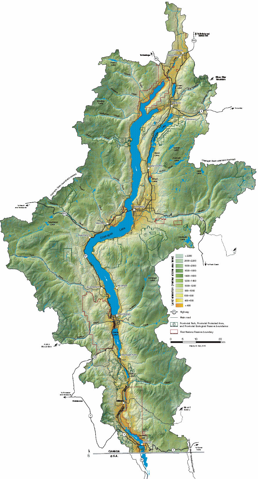
Let me back up my position with a quote from the WIKI and directly from the Okanagan Water Basin Board.The Okanagan Basin spans two countries and comprises the basin of Okanagan Lake, the Okanogan River and tributary valleys such as that of the Similkameen and Chelan Rivers. In Canada the basin constitutes two distinct regions within British Columbia, the Similkameen Country to the west and the main Okanagan region running from the communities of Osoyoos in the south to Armstrong in the north – incorporating most of the three Okanagan regional districts and is usually known as "the Okanagan" or as the Okanagan Valley or the Okanagan Country. In the United States, the Okanogan Country is the western, lowland core of Okanogan County, which like its Canadian counterpart has a history and economy based on ranching, gold, fruit orcharding and vineyards, but the basin includes Lake Chelan and other flanking valleys. Communities in Washington's Okanogan Basin include Brewster, Pateros, Omak, Okanogan, Oroville and Brewster.
https://en.wikipedia.org/wiki/Okanagan_Basin
Now from the Okanagan water basin board.The Okanagan watershed, or basin, is a narrow strip that spans from Armstrong to the US border and includes six main lakes – Okanagan, Kalamalka, Wood, Skaha, Vaseux and Osoyoos – and surrounding mountains
http://www.obwb.ca/wsd/about/state-of-the-basin
Nothing about Mt Ida, Nothing about Salmon arm.
Very northern tip of the map I linked to in my previous post (here is that link again http://www.obwb.ca/wsd/wp-content/uploa ... _large.jpg ) Is the southern slope of Mt Ida
Click on the map to enlarge
I don't give a damn whether people/posters like me or dislike me, I'm not on earth to win any popularity contests.
-
Glacier

- The Pilgrim
- Posts: 40464
- Joined: Jul 6th, 2008, 10:41 pm
Re: lidar mapping
Hassel99 wrote:Can you back that up with a source? Because you are not correct.
Zoom in on this map.
BTW, Armstrong is barely in the Okanagan...
"No one has the right to apologize for something they did not do, and no one has the right to accept an apology if the wrong was not done to them."
- Douglas Murray
- Douglas Murray
-
DarcyB
- Newbie
- Posts: 7
- Joined: Jan 14th, 2007, 12:08 pm
-
Lady tehMa

- A Peer of the Realm
- Posts: 21697
- Joined: Aug 2nd, 2005, 3:51 pm
Re: lidar mapping
The lidar mapping layer recently enabled on the City of Kelowna. It looks cool, but what actual applications could it have?
I haven't failed until I quit.
-
Grandan
- Grand Pooh-bah
- Posts: 2962
- Joined: Aug 14th, 2007, 4:05 pm
Re: lidar mapping
Hassel99 wrote:Can you back that up with a source? Because you are not correct.
Let me back up my position with a quote from the WIKI and directly from the Okanagan Water Basin Board.The Okanagan Basin spans two countries and comprises the basin of Okanagan Lake, the Okanogan River and tributary valleys such as that of the Similkameen and Chelan Rivers. In Canada the basin constitutes two distinct regions within British Columbia, the Similkameen Country to the west and the main Okanagan region running from the communities of Osoyoos in the south to Armstrong in the north – incorporating most of the three Okanagan regional districts and is usually known as "the Okanagan" or as the Okanagan Valley or the Okanagan Country. In the United States, the Okanogan Country is the western, lowland core of Okanogan County, which like its Canadian counterpart has a history and economy based on ranching, gold, fruit orcharding and vineyards, but the basin includes Lake Chelan and other flanking valleys. Communities in Washington's Okanogan Basin include Brewster, Pateros, Omak, Okanogan, Oroville and Brewster.
https://en.wikipedia.org/wiki/Okanagan_Basin
Now from the Okanagan water basin board.The Okanagan watershed, or basin, is a narrow strip that spans from Armstrong to the US border and includes six main lakes – Okanagan, Kalamalka, Wood, Skaha, Vaseux and Osoyoos – and surrounding mountains
http://www.obwb.ca/wsd/about/state-of-the-basin
Nothing about Mt Ida, Nothing about Salmon arm.
There is a monument in Armstrong that denotes that at that point all water in the valley flows south and north of that point all water flows north, in other words it is the great divide. All water flows to the valley bottom where it either flows to the north or south from that break over point.
It is a natural watershed boundary as opposed to a political boundary. That is why the mapping will use Armstrong not Salmon Arm for the starting point. Salmon Arm is on the Shushwap drainage, not Okanagan Basin
Waste not
-
kgcayenne

- Buddha of the Board
- Posts: 15019
- Joined: Aug 10th, 2005, 6:35 pm
Re: lidar mapping
Lady tehMa wrote:The lidar mapping layer recently enabled on the City of Kelowna. It looks cool, but what actual applications could it have?
It is important to also consider its limitations. Fine for broad overviews, but for doing anything specific, a proper survey is needed.
"without knowledge, he multiplies mere words."
Insanity is hereditary, you get it from your kids.
Insanity is hereditary, you get it from your kids.
-
GordonH
- Сварливий старий мерзотник
- Posts: 39064
- Joined: Oct 4th, 2008, 7:21 pm
Re: lidar mapping
At one time there was a sign in a rest stop just outside Armstrong (towards Enderby as you pass over a small bridge over Fortune creek).
That sign had arrows denoting a boundary (falsely though), left saying North Ohanagan & right saying South Ohanagan.
We know now Armstrong is north Ohanagan (northern most town).
That sign had arrows denoting a boundary (falsely though), left saying North Ohanagan & right saying South Ohanagan.
We know now Armstrong is north Ohanagan (northern most town).
I don't give a damn whether people/posters like me or dislike me, I'm not on earth to win any popularity contests.
-
Glacier
- The Pilgrim
- Posts: 40464
- Joined: Jul 6th, 2008, 10:41 pm
Re: lidar mapping
I drew the approximate boundary in RED. Armstrong is the boundary, but so is Mount Ida near Salmon Arm...
"No one has the right to apologize for something they did not do, and no one has the right to accept an apology if the wrong was not done to them."
- Douglas Murray
- Douglas Murray